Tides version 2.28 to 2.32
These notes are "in lieu" of a Manual, more information is available by pressing <F1> while the software is running.General
THE PRUDENT MARINER WILL NEVER RELY ON ANY SINGLE AID TO NAVIGATION, and this program does not pretend to replace official Tide Tables required by law on vessels at sea.The Author has taken every care in the preparation of this program but cannot under any circumstances be held accountable for any faults, errors or omissions. If you, the user, disagree, then please delete all the files that make up this program. This program is sold 'as is'. The user accepts complete and total liability and responsibility for the use of the Program, including such esoteric legalese terms as 'Indirect', 'Consequential', etc . . . If you end up hard on the putty, you can only keel-haul the Author if he was on board and swinging the lead at the time!
IF YOU CANNOT AGREE TO THE ABOVE IN LETTER AND IN SPIRIT, DO NOT - REPEAT NOT - USE THIS PROGRAM.
    ABBREVIATIONS USED:-
        <x> = the key to be pressed
        ft = Feet
        G.M.T = Greenwich Mean Time
        HH.mm = Hours and minutes
        HW = High Water
        L.S.T = Local Standard Time
        LW = Low Water
        m = meters
        No = Number

    Absolute accuracy in tidal predictions is mathematically
impossible. Barometric pressure and onshore/offshore winds can
provoke tidal height variance well in excess of one meter and no
scientist can predict hurricanes, tsunamis etc. The length of the
period of the stand or of the slack at either high or low water
can introduce major uncertainties in time.

    However, some degree of reliability is obtainable. This pro-
gram uses a new approach to rapid 'math crunching' and a strict
minimum of harmonic data compatible with the needs of Mariners. The
results obtained, when compared with published tidal predictions,
rarely diverge by more than fifteen minutes during the slacks or by
more than thirty centimeters (one foot) to Chart Datum, which can
also occasionally be in doubt. A 'Root of Mean Square' analysis over
several hundred twenty four hour periods, tends towards an accuracy
within five minutes and five centimeters.

    Program limitations have, nevertheless, to be defined:-
Tidal Range:-if this is less than approximately 0.5 meters (1.5 ft) this program may not attempt to give predictions.Shoal Waters and Estuaries:-
 are shown with notes (1), (2) and (3)
after the Port name according to reliability, as sixth diurnal harmonics
 are not used and Shoal Water Effect can therefore increase.
The practical implications for Mariners requiring at least 0.5 meters
(1.5 ft) of water under their keel are negligible. Multiply the
number in () by 10 cms (4 inches) for possible error.
Meteorological conditions:-
 can and will make a mockery of any tidal
prediction. 35 HectoPascals (Mb) or approximately 1 inch of barometric
pressure will cause a difference of 31 cms (1 ft) in tidal
height. Onshore/offshore winds, particularly in shoal waters, will
create much greater divergences.
Harmonic constants:-
 the availability and reliability of these data
are complex subjects. If available, they can be formatted to this
program relatively easily. However, some sets of constants can be
relatively incomplete, in which case this program attempts to com-
pensate for missing data. Other harmonic data may be derived from
surveys lasting as little as just a day or so. More complete, up to
date information is very often in existence but subject to copyright
or other restrictions. No data known to be in doubt has been used
here, but provision has been made for adding to, and customizing,
the data files when desired and if possible. Please contact the
Author for further information.
Dates:-
 all are valid, but beyond the 20th and 21st centuries the
simplicity of the astronomical calculations will lead to an error
of possibly +/- 10 minutes per century. Note that for dates prior
to 15 October 1582, please contact the Author and confirm your under-
standing of the Gregorian Calendar.
Help
    Individual topics are covered by pressing F1 at any stage
throughout the program. If there is more than one page, (or
screen), of Help, you will be prompted to use the Page Up/Down
arrows. The normal Up/Down arrows scroll the text one line at
a time, and might prove more convenient for some Users.

    You will rarely need help: the instruction bars (Next-To-
The-Bottom line of the screen) should be self-explanatory.

    After using Help, the program will return to exactly where
you left off before requesting Help.

    General Topics are covered by using Help and Information in
the Main Menu.
Main Menu
-  Use the Up/Down Arrows to put the highlight on the subject
of your choice, then press <ENTER>, or

-  Press the first letter of the subject, then <ENTER> . . .
Setup
    Three languages are available: English, French and Spanish. The
program will change to your new choice immediately after <ENTER>.

    There are three basic Setup modes:-
MANUAL:Every time you start the program, you will be presented with the Main Menu with "Initialize..." highlighted. If you press <ENTER>, you will be prompted to confirm or modify the Date, the last Port you used, and the time difference between L.S.T. (Local Standard Time) and GMT (Greenwich Mean Time or UTC). If you use the Main Menu for other displays, the Program picks up the Port where you left off last time, sets the time to L.S.T and uses your computer's internal Date.AUTOMATIC:
 Every time you start the program, you will be
presented with the Daily or Monthly Display (your choice), set to
L.S.T and your computer's date, of the last Port you used before
exiting the program the previous time you used it.
SAME:
 Every time you start the program, you will be
presented with the Daily or Monthly Display (your choice), set to
your Computer's date, of a Port and Time difference that you have
chosen. This option is appropriate if you wish the computer to start
every time with your Homeport and Daylight Savings Time, or a
specific Reference Port and GMT for example.

    In each instance, follow the instructions given on the next to
the last line of the screen - normally <ENTER> to accept the value
that is highlighted or the first letter of other options.

    Additional Help will be available (press F1) when you reach
the points of selecting new ports or standard times.

    For both types of automatic starts you can choose between a Daily
or Monthly display to appear immediately after the Program Title.

    Changing measurements between feet and meters, and the display
between colour and black and white, will also take place immediately
after you finally <ENTER>.
Get New GMT/LST - Setup
Three "Times" are used in this Program:-G.M.T:
Greenwich Mean Time (UTC, TU, Zulu, etc)L.S.T:
  Local Standard Time (this does NOT include Daylight
Savings, Summer Time, etc which vary locally. Some almanacs call
L.S.T "Meridian Time", "Zone Time" or "Legal Time".)
DISPLAY Time:
 Each Display shows "G.M.T +/- HH.mm" and uses
L.S.T. UNLESS you have requested modifications:-
    ==> If you have used "SETUP" to always start with the "SAME"
Port, you were prompted to enter a Time Difference on L.S.T. This
"SAME" modification will always be used until you run "SETUP" again,
even if you exit the Program.
    ==> If you have used "INITIALIZE" for a New Date and Port or
for the Monthly Display, and used <Any other key to modify>, you
were prompted to enter a Time Difference which is valid for this
session ONLY. It will NOT be retained when you exit the Program.

    The combination of these two modifications (Time Differences)
is used to convert LOCAL Time to DISPLAY Time. Every time that you
are prompted to press <Any other key to modify> the Time Difference
you will be presented with a summary of the calculation, and will
be able to re-modify it as you wish.
    Please pay particular attention to pluses and minuses. Times
ahead of G.M.T (normally of East longitude) are positive (+), those
behind G.M.T (for example, the Americas) are negative. Note that
you do not have to type a "plus" as any number that is not preceded
by a minus sign is automatically positive.

    If you wish the program to start systematically with a fixed
time Difference on LOCAL time (Daylight savings, etc), press <D> if
it is not already highlighted and type in, using minus if required,
the difference from L.S.T that you want.
    When you are satisfied with the highlighted result, <ENTER>.

    If you wish to start systematically with LOCAL time, ensure that
"<L>ocal" is highlighted; if it is not, type <L> or "0" (Zero).
NOTE:-A fixed time difference (the <D>ifference on the screen now) will apply to ALL Ports used during the current session, but each time you initialize a new Port you will be given the opportunity to change the relationship between G.M.T and Local Standard Time, and further detailed help will be available.
Daily Display
    The display should be self-explanatory, (times of high and low
waters - HW and LW - are given according to the GMT +/- below the
graph), as should be the graph itself.
    Some areas of diurnal tides have a stand or periods of slack
water that appear clearly on the graph, but which will not appear
as a High or a Low unless there is a clear change in the tidal flow.
This might differ from some published Tide Tables.
MENU:- Next and Previous days need no explanation. Use the
up/down arrows of your keyboard to select, then press <ENTER>.
"Height at a given time" and "Time of a given height" will
ask you to type then <ENTER> your request. If your request is very
close to a period of slack water, the mathematical algorithms used
may vary your request to avoid trouble with "rounding out". Once
you have an answer, any key will put you back to the Menu.
For the "Closest Tide" or for a "List of Heights between two
times", please return to the Main Menu.
Monthly Display
    This will really tell you how fast your computer is! A
486DX takes about one second, an older 286SX takes seven to
twelve seconds. The graph might redraw itself a few times while
it sorts out the scale.
    To scroll the table, use either Page Up/Page Down to jump
about a week at a time, or the normal Up/Down arrows to scroll
one day at a time.
    Pressing Left or Right Arrows will give you the previous or
the next month.
    Pressing <F6> will take you to the facility allowing you to
printout the Table, and further Help will be available. Note that
this printout is not available in unregistered Programs.
Monthly Listing
    To accept displayed values just <ENTER>, to make any changes
press <any other key>.
    If you choose to modify the Date, by pressing <any other key>
then the Month, then the Year will appear in turn, each one
prompting you with the last value used. Just <ENTER> to reuse the
last value, or type in, then <ENTER> a new value. You will be advised
if the computer cannot handle your input (for example if you
attempt a thirteenth month!)
    After setting the date, if you want to change Ports, do not
<ENTER>, press <any other key>, then type in the name of the Port
you require. If the Port is in the same Region, the Program will
find it, otherwise you will be prompted to search in the Regional
lists. Further Help (F1) will be available when you get to the
"File Service Menu".
Print Monthly Tables
    A printer with limited graphics capability is assumed in order
to draw the boxes around the columns of the table. Daisy wheel type
printers reproduce the data correctly, but can print some amazing
boxes!
    If your printer is not on line, or is out of paper, an error
message will appear; you can either correct the malfunction or press
any key other than <ENTER> to return to the start of the print
routine, then back to the Monthly Display.
File Service
    This facility is used from the Main Menu, Reference list . .,
from Initialize New Port, and from Setup, Automatic.
REGIONS: Select the Region you require by using the Up,
Down, Left or Right arrows. Note that Spare, Custom and Private
Regions will normally be "Not Available" if selected, as will be
some regions in "Demonstration" programs. These are reserved
for Customized versions of this program - please contact the
Author.
For convenience, some regions overlap. Example - "Gibraltar"
appears in both the Mediterranean and Spain (Atlantic Coast).
If you are not sure which region you should be searching in,
please use "Select using Lat./Long - see below.
PORTS: Select the Port you require by using the Up, Down,
Left or Right arrows, then <ENTER>. If you change Port, you will
be asked for confirmation before your selection takes place.
For the sake of putting as many Ports as possible on one screen
the longer names are truncated. The confirmation will give the full
name, so this should not pose a problem.
The spelling of Port names is somewhat aleatory. If an inter-
nationally accepted name has been found, it is used; if not, the
Author has based his choice on his own maritime experience, using
local or anglicized choices.
The Ports will appear in the order that they are found in the
data files, normally alphabetic. However pressing <F9> will allow
you the choice of resorting either by latitude or by longitude and
then returning to alphabetic. (After <F9>, press <T> for lat., <G>
for long or <A> for alphabetic).
You can select the port from any sorted list by pressing <ENTER>
and although each Port will display it's full name and Lat./Long
on the next confirmation screen, precisions are sometimes included -
"River entrance", "Muelle", etc., for the sake of clarity.
Notes (1),(2) and (3) after a port name give some idea of
accuracy - see "General"
SELECT USING LAT/LONG: Select (Up/Down arrows) and <ENTER>,
then press F1 again for detailed Help.
MAIN MENU:Select and <ENTER> will return you to the Main Menu with no changes to your selected Region or Port.
Port selection by Lat./Long
    By default, the search will be for all other Ports within plus
or minus 3 degrees from the position (to the nearest whole degree)
of the Port you are currently using. Press <ENTER> twice.
    To modify the CENTER position of the search area, press any key
other than <ENTER>, then type in the Lat./Long required.
Example:- 51N <ENTER>
7W <ENTER>
Note that leading zeros are not required, nor are capital/upper
case letters for N, South, e or west.
Attempting to search for ports in inland areas could lead to
surprises. The Gobi desert is not tidal (we think?)
To modify the LIMITS of the search area, after setting the
center, press any key other than <ENTER>, a number from 1 to 9 to
replace the 3 degree default value, then <ENTER>. This is specially
useful in areas with a high density of Reference Ports, try 1 or 2
degrees, or sparse areas (e.g. Antarctic), try up to 9 degrees.
Ports found in Search Area
    Use the up/down arrows (left/right if there is more than one
column) until the highlight is on the Port you require, then <ENTER>
    You may also return to the Menu retaining your previous Port
selection.
Select a New Port
    Use the Up/Down/Left Right arrows to put the highlight on
the Port of your choice, then <ENTER>. You will be asked for
confirmation and will therefore have the possibility to go back
and reselect. <F9> allows you to sort the list by latitude or
by longitude rather than alphabetically
.
Initialize New Port
    Use the Up/Down/Left Right arrows to put the highlight on
the Port of your choice, then <ENTER>. You will be asked for
confirmation and will therefore have the possibility to go back
and reselect. <F9> allows you to sort the list by latitude or
by longitude rather than alphabetically.
    You will then have the possibility of accepting or modifying
the difference between Local Standard Time and GMT
Initialize Date and Port
    To accept displayed values just <ENTER>, to make any changes
press <any other key>.
    If you choose to modify the Date, by pressing <any other key>
then the Day, then the Month, then the Year will appear in turn,
each one prompting you with the last value used. Just <ENTER> to
reuse the last value, or type in, then <ENTER> a new value. You
will be advised if the computer cannot handle your input (for
example if you attempt the 31st day of February!)
    After setting the date, if you want to change Ports, do not
<ENTER>, press <any other key>, then type in the name of the Port
you require. If the Port is in the same Region, the Program will
find it, otherwise you will be prompted to search in the Regional
lists. Further Help (F1) will be available when you get to the
"File Service Menu".
    Note that the program will allow you some spelling mistakes.
If you get the first half of the name nearly right, you may well
be asked: "Exact name not found - do you require xxxxx ?". Accept
by pressing <ENTER>, continue with any other key. For example, if
you request "Saint ", you might be asked if "SAINT JO", then
"SAINT JOHN", then "SAINT THOMAS" are what you need. Upper and
Lower case letters are all the same for input to the program.
    As a last resort, you will be prompted to use only the first
letter of the Port name. Again, press <ENTER> if the displayed
name is the one you want, <any other key> to continue to search.
Remember that these search options only apply to the Region you are
currently in.
    After selecting the port, you will be asked about setting Local
Time - further Help will be available by pressing <F1>.
Heights in Meters or Heights in Feet at regular intervals
    This facility will produce a list as follows:-

                    Height:- 2.47 at:- 12.00
                    Height:- 2.51 at:- 12.05
                    /....
                                     ..../
                    Height:- 4.93 at:- 14.00

                    after a request for tidal heights for every
five minutes from Noon to 2 p.m.

    After entering the Start and End times for the list (use the
24 hour system, then a full stop/period, then the minutes if you
need them) and the interval in Minutes between the heights, you
will be asked for confirmation. You can at this point go back and
change your input by pressing any key except <ENTER>.

    The list will appear in two columns: if there is not enough
room on the first screen, you will be prompted to move down the list
by pressing <ENTER>, which will also take you back to the Main Menu
from the end of the list, or by pressing  to move back up to
Previous Pages.

    To change from Meters to Feet or vice versa, use Setup and Con-
figuration in the Main Menu.

    To PRINT the list, press <F7> and follow the instructions. There
is a limit of 256 Heights and Times which means that if you require
a longer list - which can be viewed on the screen - to be printed,
you will have to do it in more than one print job. However, as this
would be a list of over 4 hours spaced every minute, or the whole
day at less than 8 minute intervals, it should not be a problem. It
will be produced on a maximum of three sheets of paper, and will
pause for a new sheet between each one.

Note that the heights in feet will be printed to two decimal places,
which is definite overkill, but allows the same format as in meters.
Closest High/Low water
    This facility produces the following, for example:-

                " High (3.57 Meters) at 09.03 "

after a request for a time of 08.30 hours.
    Enter the time (24 hour system: Hours, then a full stop/period,
then the minutes if you need them) closest to which you require the
time of the nearest High or Low water.
    You can repeat this several times by pressing any key other than
<ENTER>, until the screen is full.
    Pressing <ENTER> will return to the Main Menu.
Installation
From ZIPped file:-
Unzip to a new Directory/Folder e.g. "Tides",
type in "Personal Code Number" as requested during first start up.
From diskette:-
Run "INSTALL.EXE" from the diskette and
follow on screen instructions, inserting your "Personal Code Number" that
came with the diskette when requested by the Install software, not later,
when the program is running (as for ZIPped files). The Code Numbers
are NOT the same.
WINDOWS 95:
In "Explorer" or "File Manager" make a shortcut to the "Tides.bat"
file (see you Win95 documentation or Help files for how to do this) and
set "Properties", "Program", "Advanced" to prevent this DOS based program
from detecting Windows (you may follow the complete recommendation in
Tech Note T11-97 below).
	The various screens should appear as follows:
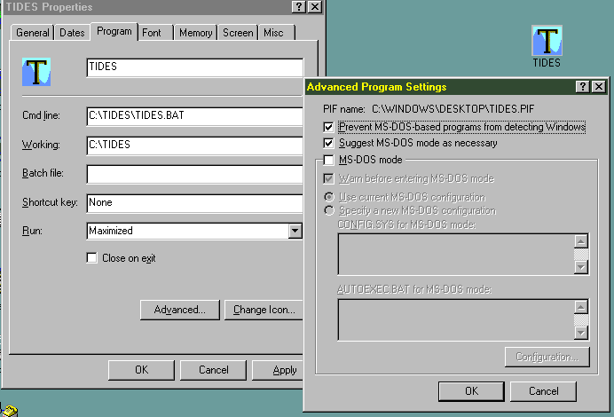
	We have included an icon as above, that can be installed using
the "Change Icon" button as in the image above.
TECH NOTE T11-97 (Video failure Win95, including Networking)
Important:- Although this note applies specifically to a very rare problem,
the method described here is appropriate for smooth operation of the
software in any Window 95 installation.
Program: TIDES version 2.26
Problem: possible system crash accessing monthly data page under Win95
Cause: Windows 95 erratic screen paging with certain video boards. This
is a hardware, not a software, failure.
WORKAROUND:
1 - Make a shortcut to TIDES.BAT

2 - Open the Properties to the shortcut, and use "Apply"/"OK" for the
following:
        a) Program:
                Run Maximized
                In Advanced:
                        Prevent MSDos detecting Windows
                        Suggest MSDos mode as necessary
        b) Memory:
                Set all boxes to Auto
                Check HMA
        c) Screen:
                Set to "Full Screen" and Initial Size to "25 lines"
                All else unchecked
        d) Misc.:
                All unchecked/Off except "Warn if still active"

        The above has been tested successfully under Win95/Microsoft Client LAN
conditions using a video adapter that had been previously known to crash
the software.
Software Registration
      ALL MESSAGES ON THIS SUBJECT WILL DISAPPEAR FOR EVER . . .
unless you edit or otherwise modify any of the files.
    This program works very slowly off a floppy, so copy all the files
to a Directory on your Hard Disk. Please note the program's Serial Number
which is necessary for your Registration. After receipt of your payment
you will be given a Personal Code Number which, after you have typed
it in, will eliminate these messages.
    Programs sold via retailers, and therefore pre-paid, require
you to type in the Code Number supplied in writing in the accompanying
documentation, during the installation carried out by the
INSTALL.EXE program. If you do not use the supplied INSTALL.EXE
you will have to contact us AFTER installation for your personal
code number. Only programs working directly off the original
floppy disk can be pre-initialized, and this is not recommended, it
is very slow.
    Note that Registration is limited to the use of one computer
only; for multi-systems, please contact us.
Error Message
   Hopefully you will never see this section.

    However, if it does occur, please advise the Author, with
a brief description of how things happened so that the error
can be reproduced, then corrected.

    If you are a Registered User of the Program, an update
will be sent to you if the Program has to be modified. Note
that this offer does not apply to User Errors or Data Errors.
Missing or Corrupt Data
    Please contact us.
    If you are a Registered User, you may try re-Installing the
Program from your floppy, and retyping your Personal Code
Number.
    This Message should only appear if one or more files have
been modified, edited or deleted, and is often a symptom of
Software piracy. However this program may be used for trial
purposes prior to Registration with no modifications to the
original files. If you are experiencing difficulties during
genuine trials, please contact us and advise us as to where
you obtained your copy from.
    If your information leads to the conviction of any person
under applicable copyright or other laws, we will be happy to
supply you FREE REGISTRATION of this Program.
Software Program message
    This screen will only appear if you attempt to use this
Program more than 10 times without typing in your Personal
Code Number which will be given to you at the time that you
register, or if certain Files are missing or have been edited
or otherwise modified.
    If you are a Registered User please contact us
Credits
    This program is Copyright 1994 - 2002, Stormy Weather
Software Ltd. It was written on an Amstrad 4286 SX 25 and a Grey
Tech 486 DX 33, using Microsoft DOS 6.2, PC Tools Pro 9.0 from
Central Point Software and Microsoft Basic. It has been updated on
a GrayTech Pentium II 266 under Win950b.
    It was verified using tables published by the British Admiralty,
the French SHOM and in other Almanacs using data from various nat-
ional Hydrographic Services. Special recognition is extended to the
Canadian Hydrographic Service, Ottawa and the Institute of Ocean
Sciences, Sydney, B.C.
    Amstrad, Central Point Software, Grey Tech and Microsoft are
Trademarks of their various corporate owners.